
Súbor:TurksandCaicosOMC.png

Veľkosť tohto náhľadu: 800 × 554 pixelov. Iné rozlíšenia: 320 × 222 pixelov | 640 × 443 pixelov | 969 × 671 pixelov .
Pôvodný súbor (969 × 671 pixelov, veľkosť súboru: 32 KB, MIME typ: image/png)
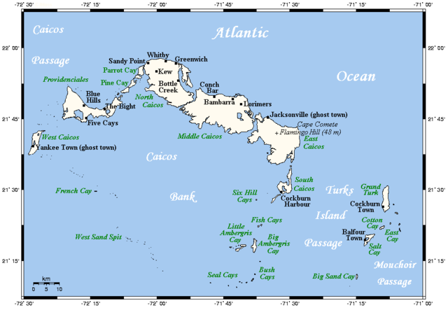
| Popis | A map showing the Turks and Caicos Islands' main towns and islands. This map's source is here, with the uploader's modifications, and the GMT homepage says that the tools are released under the GNU General Public License. | ||||||||
| Dátum | |||||||||
| Zdroj | Originally uploaded by Kelisi to en:Wikipedia (log). | ||||||||
| Autor | Kelisi (talk) | ||||||||
| Povolenie (Využívanie tohto súboru) |
Kelisi at the English language Wikipedia, držiteľ autorských práv k tomuto dielu ho týmto zverejňuje za podmienok nasledovnej licencie:
|

História súboru
Po kliknutí na dátum/čas uvidíte ako súbor vyzeral vtedy.
| Dátum/Čas | Náhľad | Rozmery | Používateľ | Komentár | |
|---|---|---|---|---|---|
| aktuálna | 21:46, 4. apríl 2021 | | 969 × 671 (32 KB) | Kelisi | Newly discovered fact |
| 10:27, 21. december 2009 |  | 969 × 671 (25 KB) | Xfigpower | {{Information |Description=A map showing the Turks and Caicos Islands' main towns and islands. This map's source is [http://www.aquarius.ifm-geomar.de/ here], with the uploader's modifications, and the [http://gmt.soest.hawaii.edu/ GMT homepage] says that |
Použitie súboru
Na tento súbor odkazuje nasledujúca stránka:
Globálne využitie súborov
Nasledovné ďalšie wiki používajú tento súbor:
- Použitie na af.wikipedia.org
- Použitie na als.wikipedia.org
- Použitie na ar.wikipedia.org
- Použitie na br.wikipedia.org
- Použitie na bs.wikipedia.org
- Použitie na en.wikipedia.org
- Použitie na en.wiktionary.org
- Použitie na es.wikipedia.org
- Použitie na fa.wikipedia.org
- Použitie na hr.wikipedia.org
- Použitie na id.wikipedia.org
- Použitie na it.wikipedia.org
- Použitie na ja.wikipedia.org
- Použitie na ln.wikipedia.org
- Použitie na lt.wikipedia.org
- Použitie na mk.wikipedia.org
- Použitie na pt.wikipedia.org
- Použitie na ru.wikipedia.org
- Použitie na sh.wikipedia.org
- Použitie na simple.wikipedia.org
- Použitie na uk.wikipedia.org
- Použitie na vi.wikipedia.org
- Použitie na zh.wikipedia.org