
Súbor:Partition of Hungary.png
Nie je dostupné vyššie rozlíšenie.
Partition_of_Hungary.png (389 × 328 pixelov, veľkosť súboru: 31 KB, MIME typ: image/png)
Zhrnutie

| Popis |
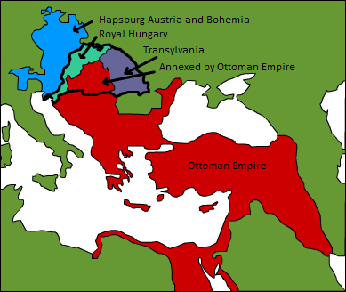
A map displaying position of the Kingdom of Hungary before 1541, and the 3 parts into which it was divided after the occupation of Buda in 1541: Royal Hungary, Eastern Hungarian kingdom, and the part that was annexed by the Ottoman Empire. en:Category:Maps of the history of Hungary |
| Dátum | 3. septembra 2006 (datum prvotního načtení souboru) |
| Zdroj | Transferred from en.wikipedia to Commons. |
| Autor |
Esoltas v projekte Wikipédia (angličtina) Later versions were uploaded by PANONIAN, DonatusHR at en.wikipedia. |
Licencovanie
| Toto dielo uvoľnil ako voľné dielo (public domain) jeho autor, Esoltas v projekte Wikipédia (angličtina). Toto platí celosvetovo. V niektorých krajinách to zákon neumožňuje; v tom prípade: Esoltas udelil komukoľvek právo používať toto dielo na ľubovoľné účely, bez akýchkoľvek podmienok ak také podmienky nevyžaduje zákon. |
Pôvodný záznam nahrávaní
The original description page was here. All following user names refer to en.wikipedia.
- 2007-08-12 15:14 DonatusHR 389×328×8 (38357 bytes) Vraćeno na prijašnju inačicu
- 2007-08-12 15:13 DonatusHR 389×328×8 (35596 bytes) Vraćeno na prijašnju inačicu
- 2006-10-11 10:58 PANONIAN 389×328×8 (38357 bytes) corrected image
- 2006-09-03 15:00 Esoltas 389×328×8 (35596 bytes) A map displaying the original position of the Kingdom of Hungary, and the 3 lands that became of it after the Battle of Mohács: Royal Hungary, Transylvania, and the Ottoman-occupied section.
História súboru
Po kliknutí na dátum/čas uvidíte ako súbor vyzeral vtedy.
| Dátum/Čas | Náhľad | Rozmery | Používateľ | Komentár | |
|---|---|---|---|---|---|
| aktuálna | 17:22, 12. február 2016 | | 389 × 328 (31 KB) | Packare | better caption |
| 17:58, 10. september 2007 |  | 389 × 328 (37 KB) | Sir Iain | {{Information |Description=A map displaying position of the Kingdom of Hungary before 1526, and the 3 parts into which it was divided after the Battle of Mohács: Royal Hungary, Transylvania, and the part that was annexed by the Ottoman Empire. [[:en:Ca |
Použitie súboru
Na tento súbor odkazuje nasledujúca stránka:
Globálne využitie súborov
Nasledovné ďalšie wiki používajú tento súbor:
- Použitie na ar.wikipedia.org
- Použitie na azb.wikipedia.org
- Použitie na de.wikipedia.org
- Použitie na el.wikipedia.org
- Použitie na en.wikipedia.org
- Použitie na es.wikipedia.org
- Použitie na fr.wikipedia.org
- Použitie na gl.wikipedia.org
- Použitie na hu.wikipedia.org
- Použitie na io.wikipedia.org
- Použitie na it.wikipedia.org
- Použitie na ja.wikipedia.org
- Použitie na ko.wikipedia.org
- Použitie na lv.wikipedia.org
- Použitie na nl.wikipedia.org
- Použitie na trv.wikipedia.org
- Použitie na tr.wikipedia.org
- Použitie na uk.wikipedia.org
- Použitie na uz.wikipedia.org
- Použitie na zh.wikipedia.org